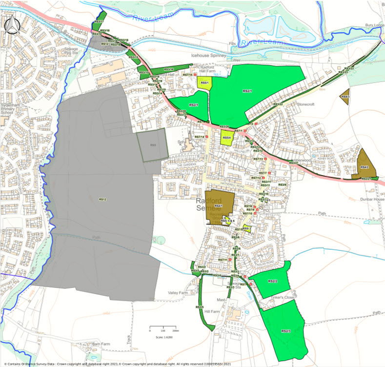
Radford Semele Neighbourhood Plan Interactive Policy Map

You can move around and zoom in and out of the map below.
You may view the individual elements of the Policy map points be selecting or deselecting a layer using the pull down menu on the map.
Please note we are aware that this feature does not fully work in Safari. Use Chrome, Firefox or Edge instead. Alternatively the full policy map can be viewed in the Neighbourhood Plan document (Page 27) available to view or download from the Neighbourhood Plan page.
The detail for each of the Policy reference points are in the current version of the Neighbourhood Plan that can be downloaded below.
Key to the Policy Points:
Policy RS2 – Identify and protect our Local Green Spaces
- RS2/1 – Church Fields West & East
- RS2/2 – Leigh Foss
- RS2/3 – Angley Hole and Woods
Policy RS3 – Protecting Small Open Spaces
- RS3/1 - Green in front of village shops
- RS3/2 - Green verges and hedges at the end of Valley and Williams Roads
- RS3/3 - Green spaces at the end of Valley, Lewis Roads and The Valley, where the track to Hillside Farm leads off the road, together with a triangular island on the junction.
- RS3/4 - The ditch, hedge and verge leading all the way along Valley Road and the Valley to the LWS 'Angley Hole'
- RS3/5 - The Greenway, South of Valley Road, a wide footpath, W120B connecting paths W120 and w119.
- RS3/6 - Area of sloping grass verge to the South of the junction of St Nicholas and Lewis Road.
- RS3/7 - Hedgerow to the East of Lewis Road from St Nicholas Road to The Valley.
- RS3/8 - Verge North of the junction of Godfrey Close with Lewis Road.
- RS3/9 - Small roundabout at the end of Overtons Close.
- RS3/10 - Verge North of the junction of Lythall Close with Lewis Road.
- RS3/11 - Verges North and South of the junction of Overtons Close with Lewis Road.
- RS3/12 - The 2 wide verges either side of the junction of Hall Fields with Southam Road.
- RS3/13 - The verge between the service road at the junction of Southam Road with Kingshurst.
- RS3/14 - The verge and hedge beside Leam View.
- RS3/15 - The area beside and in front of Ricardos, including lawn, trees and part of the old railway cutting, which is wooded.
- RS3/16 - The wooded and scrub area of the old railway cutting on the side of Southam Road opposite Ricardos.
- RS3/17 - An area of boggy scrub and grassland North of the Southam Road at the end of the layby near the canal which is bordered by the Parish boundary Radford stream and River Leam.
- RS3/18 - The hedges and verges either side of the Southam Road from the Parish boundary to the Canal on the South side and the old railway cutting on the North side.
- RS3/19 - The lawn verges outside Radford Hall.
- RS3/20 - Verge to the N of Southam Road from Radford Hall to the junction with Offchurch Lane.
- RS3/21 - Verge and hedge from opposite Hall Fields, past the bus stop to the junction with the road to Semele Park.
- RS3/22 - Verge along NW of Offchurch Land, by footpath.
- RS3/23 - Steep verges on both sides of Offchurch Lane beyond the footpath leading from the village.
Policy RS4 – Recognise, protect and enhance our Sport and Recreation Facilities
- RS4/1 - Village Playing Field/Recreation Ground
- RS4/2 - Semele Park South, recreation and children’s playing area
- RS4/3 – Future Semele Park North, recreation and children’s playing area
Policy RS5 – Protection of Community Facilities
- RS5/1 - Parish Church of St Nicholas
- RS5/2 - Baptist Church
- RS5/3 - Village shops, including Post Office
- RS5/4 - White Lion Public House RS5/5 - Community Hall
- RS5/6 - Sports and Social Club
- RS5/7 - Radford Semele Church of England Primary School
Policy RS6 - Conserving and Enhancing Radford Semele’s Landscape Character (Community Valued Views)
- RS6/1 – view east from Canal Bridge when entering Radford Semele from Leamington;
- RS6/2 – view of Church and Church Fields from corner of A425/Offchurch Lane;
- RS6/3 – view east looking from St Nicholas Graveyard;
- RS6/4 – view looking east from corner of Semele Park development;
- RS6/5 – view from Valley Woods looking south-east;
- RS6/6 – view from Valley Road Looking south-east, and RS6/7 – views from Crown Hill Trig Point.
Policy RS7 – Recognise our important Non-designated Heritage Assets in the village
- RS7/1 - The Manor (Also known as The Gable End House) Corner of Offchurch Lane/Southam Road.
- RS7/2 - Manor Lodge, Offchurch Lane.
- RS7/3 - The Baptist Church, Lewis Road.
- RS7/4 - 29 and 30 The Valley.
- RS7/5 - 1-3 The Valley.
- RS7/6 - Site of Ancient Village Stocks.
- RS7/7 - Nos 5-15 Lewis Road.
- RS7/8 - No. 50 Lewis Road.
- RS7/9 - Nos. 43-51 Lewis Rd.
- RS7/10 - Briar Cottage, No. 53 Lewis Rd.
- RS7/11 - 102 and 104 Lewis Road.
- RS7/12 - No. 20/22 Lewis Road.
- RS7/13 - The Old Bakery, No. 2 Lewis Road.
- RS7/14 - The Elms, No. 6 School Lane.
- RS7/15 - Original Barn building, Radford Hall Farm, Church Lane.
Policy RS12 – Ensure that we maintain the Area of Separation between Radford Semele and Leamington Spa
To ensure that Radford Semele village remains a distinct, separate settlement and to prevent coalescence with Royal Leamington Spa, Sydenham and Whitnash, the Area of Separation identified in Policies Map 8 will be maintained. This area lies to the west of Radford Semele and extends up to the Parish boundary.